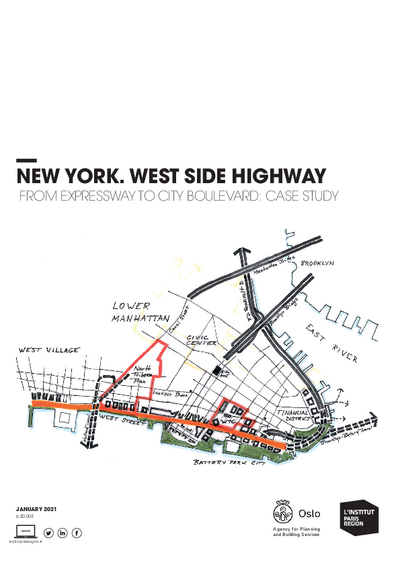
New York. West Side Highway
Starting in the late 1920s, New York adapted to the fast growing automobile use: with the white middle-class moving to live in the suburbs, new highways were carved through the working-class minority neighbourhoods to allow fast access to downtown job, shops and entertainment.
The West Side Highway was one of the first elevated highways mostly built between 1927 and 1931 along the Hudson piers on the west side of Manhattan, connecting with the city’s dense highway network and circling the entire island. Until 1973, when it collapsed by lack of maintenance, West Side Highway carried a very high volume of traffic, between 140,000 and 110, 000, blighting the deprived neighbourhoods. Following the accident, the 8-km long expressway viaduct had to be closed to traffic: engineers were baffled, as part of the traffic just disappeared.
After thirty years of standstill, alternative highway projects, court-cases, and redevelopment work, a new finally at-grade 6- to 8-lane boulevard replaced the West Side Highway in 2001. Traffic volumes have been reduced by a third to around 80,000 vehicles per day, traffic speeds and accidents have reduced, and the new street reconnects the city with the Hudson River and the Hudson Riverfront Park. Pedestrian and bicycle mobility (5-6,000 bikes per day) has dramatically increased. And the area is currently being entirely regenerated, with developers and big names in architecture jostling to build housing in areas formerly devalued by the expressway.
The West Side project demonstrates how a new urban avenue can successfully replace a highway with high traffic volumes, while improving overall mobility and continuing to play an essential role in the functioning of the metropolitan region.
This study is linked to the following themes :
International |
Urban planning