Barcelona, Metropolitan Avenues
Barcelona is a dense and compact city of 1.6 million people living on a small territory of 100 km² framed by the Collserola mountains, the sea and the Besos and the Llobregat rivers. Together with 35 other municipalities, it makes up for the Barcelona Metropolitan Area (Àrea Metropolitana de Barcelona, AMB), the metropolitan authority covering an area of 636 km2 (48% built up). The Barcelona Metropolitan Area was legally established as an institution in 2010 bringing together powers in the fields of urban planning, transport, and the environment.
The future Metropolitan Urban Master Plan (PDUM) steered by the AMB identifies the transformation of axes such as the Meridiana Avenue and the C- 245 Road in the lower Llobregat delta or the N-150 Avinguda del Vallès as projects of metropolitan interest with a supra-municipal character. As guidance for the development of 36 municipalities to 2042 and beyond, the PDUM has opened-up a unique opportunity to rethink mobility, grey and green infrastructure, urbanisation, and long-term resilience of the metropolitan region. The PDUM puts forward a spatially and socially balanced metropolitan development, less focused on international competition and attractivity, and more on providing alternative mobility, and recycling the existing urban space, thus limiting urban expansion.
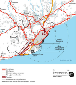
Barcelona Metropolitan Area’s road network with C-245 and Meridiana project areas © OpenStreetMap, Barcelona Metropolitan Area, L'Institut Paris Region
The AMB has established a first list of its priority corridors for the Metropolitan Avenues strategy, some projects have already started.
The Meridiana Avenue
The Meridiana Avenue is a 7.7 km long avenue built in the 1950s as a major throughway of the city. With the first metro line of the city (L1) built under the surface of the avenue, the axis became the backbone of the north-eastern extension of the city. From 1964 to 1967, the Meridiana was transformed into a 12-lane highway with six segregated central lanes for fast traffic lanes connecting with the AP-7 northern motorway (and later to the C-17, C-33 and C-58 expressways) and six side lanes for local traffic.
By 1989, the newly elected democratic government of Barcelona initiated the process of humanizing the Meridiana highway. Despite this evolution and the fairly good metro connections (5 metro stations are located along the avenue, including a regional train station), the Meridiana remains a highly polluted road and a major barrier between neighbourhoods for pedestrians and cyclists.
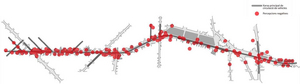
The Meridiana workshops pinpointed negative perceptions by users (red dots) including: too many cars, lack of safe and comfortable crossings, conflictual bike lanes, inadequacy of street lighting and the poor esthetic design of the axis © Ajuntament de Barcelona
In 2015, the Urban Ecology department of the City of Barcelona, in charge of the urban planning and infrastructure, launched an open participative process to initiate a future transformation of the Meridiana. Since 2018, the Meridiana project is incrementally being delivered by BIMSA, the Barcelona Municipal Infrastructure Agency. In summary, the 7,7 km long Meridiana Avenue Project aims to reduce the number of general traffic space of the axis by over a third, taking away at least two lanes from general traffic and at some places more. If everything goes as envisioned, this may allow to give over 10 hectares of roadway back to green space (trees, plant beds, rain-water gardens). In the completed and decided sections, 38% of tarmacked roadway on average is due to be removed and 6.4 hectares of green will be created.
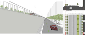
Cross section sketch at Can Drago/Sant Andreu (section 3) to the north of Meridana before with 4+4 traffic lanes (1 for busses) built above the train tracks with a blanck wall separation from the side street © Ajuntament de Barcelona
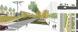
One option for the future cross section of Meridiana after at the same place (section 3) with 3+3 traffic lanes, the replacement of the wall by a sloped median (linear park) and the relocation of the northbound roadway. © Ajuntament de Barcelona
The C-245 Road
The historical road C-245 is the backbone of the urbanisation of the lower Llobregat delta in the southwestern periphery of Barcelona. However, the territory crossed by the road suffers from important physical discontinuities and social segregation, although the C-245 does play an important structuring role in the territory both for the connection of metropolitan centres and internally between neighbourhoods. Over the past decades, the C-245 Road has been the subject of various studies and projects in response to the demand of local councils to transform it into a better connected, people-friendly, street.
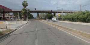
The C-245 Road as a dual carriageway in the municipality of Gavà © P. Lecroart / L’Institut Paris Region
The C-245 project is 13-km long, from plaça Constitució in Castelldefels to the multimodal train and tramway interchange in Cornellà. One of the main characteristics of the road is its supra-municipal nature, as it connects five municipalities in the Llobregat delta to the city of Barcelona. The main initial goal of the project is to improve the public transport offer. A secondary goal emerged during the preparation of the project, in line with the Barcelona Metropolitan Area (AMB) Bicivia Plan 2016 (Bikeway Plan): to create a continuous new metropolitan bike connector along the route. Beyond the C-245 project, specific actions were taken on by some municipalities.
The current ongoing C-245 project includes the following components:
- A dedicated busway along most of the route with centralised bus stops and a bus priority system for traffic-lights: this should increase commercial speed by 25% in the urban sections. A highperformance metropolitan bus system with a fleet of 12 articulated buses, initially hybrid and later electric will be implemented.
- Inter-mobility with existing transport hubs (metro, tram, or regional express train network) and with secure bicycle parking facilities (AMB Bicibox).
- Integration of the Bicivia 7 metropolitan bikeway with a continuous and separate cycle lane. This bikeway will be extended beyond the project linking Casteldefels to Barcelona.
- Redesigning of the central roadway (but not the side lanes) and enlarging the sidewalks along the road with quality paving material and new lighting furniture.
- Increasing the number of pedestrian crossings as a contribution to the cohesion and unity of the project and the surrounding urban areas.
- From a legibility perspective, the new urban axis will be structured around three large (lightly) redesigned roundabouts: Plaça Colom (Castelldefels), Plaça del Tanatori (Viladecans) and Plaça Parellada (Sant Boi de Llobregat).
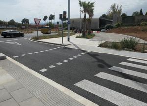
The C-245 project follows high quality design and delivery requirements. Notice the details of the pavement design. © P. Lecroart / L’Institut Paris Region
The initiative of approaching the transformation of the C-245 through a unitary project was taken on by the Barcelona Metropolitan Area (AMB). The project is now steered by the Department of Territory and Sustainability of the Generalitat of Catalonia, the institution in charge of the road and carrying out the work. The coordination of the local municipal councils is supported by the AMB. Ownership and management of the road will be transferred to the municipalities once the work is completed. Each section of the project was discussed locally by the municipalities, who saw the unitary project as a tool to contribute solving local problems. This led to new requirements being incorporated into the initial design, with a consequent increase in the initial budget. The five different lots of the project were awarded to five different companies to carry out the execution of the construction. This unusual formula requires a strict coordination and control by both the Generalitat and the lead designers. The project is currently underway. Work started in 2021 and is expected to end in 2023.
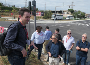
A site visit of the works on C-245 road with Joan Caba Roset (AMB) and Bernardo de Sola, lead architect in July 2022 © P. Lecroart / L’Institut Paris Region
It is too early to assess the C-245 project as the new street and new express bus system are not fully in service. However, after many decades as a suburban road, the C- 245 will soon become the13-km long unified avenue of the Lower Llobregat -it could be re-branded as such. For the local communities as well as for the Metropolitan Area (AMB), this is a game changer and a huge step forward: the new bus and bike avenue integrates four suburban towns as part of metropolis (Cornellà is already integrated). It significantly improves the quality of public space, supporting new social uses and better walkability, as a potential driver for urban regeneration and new development.
This report is about Barcelona’s Metropolitan Avenues strategy with the C-245 Regional Road and the C-33 Meridiana Avenue as pilot-projects. The conversion of the 13-km long C-245 shows the way a metropolitan authority can help to redesign a suburban road into a civic street connecting five municipalities with a busway and a bikeway. The Meridiana Avenue story is about the 30-year long transformation of a former 1960s 7.7 km-long boulevard first into an urban expressway, in the 1990s into a heavily trafficked avenue, and now, in the 2020s, into a greener, pedestrian- and bike-friendly, avenue. Barcelona’s city and metropolitan experience offers an inspiring insight into how we can tackle these issues, now and in the future.
This study is linked to the following theme :
Urban planning