Greater London vs. Paris Region: What public transport provision?

31 January 2015ContactFrédérique Prédali & Simon Gloaguen

Report on mobility and transport #1, November 2014

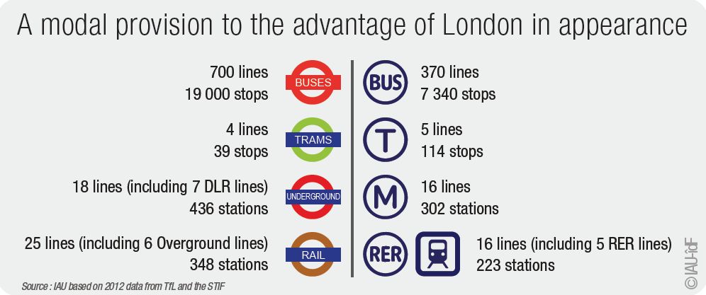
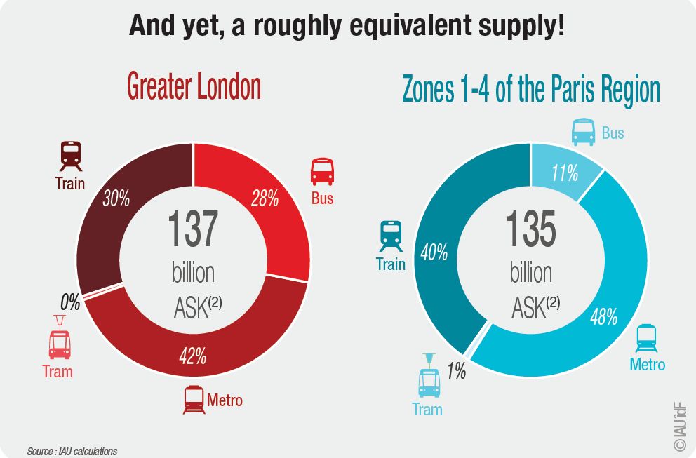
Greater London, often considered to be less efficient in terms of public transport infrastructure compared to the Paris Region, is continually improving its network and this trend has accelerated since the preparation of the 2012 Olympic Games. For the first time, their respective public transport provision can be measured precisely using data from operators. Groundbreaking results!

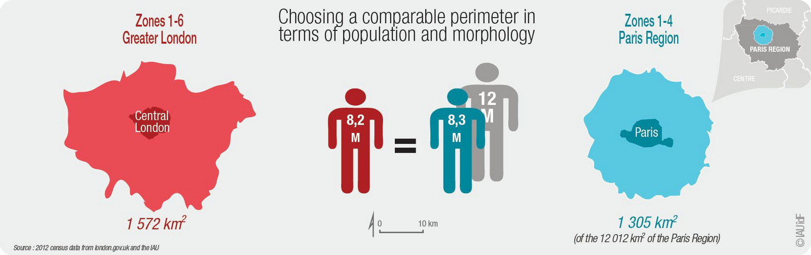
Finding the right perimeter for comparison

If the challenges faced by these two major cities are often similar, their territorial and administrative organizations differ to the point that it is difficult to compare.
The perimeter selected in the Paris Region in comparison with Greater London is that of fare zones 1 to 4 of the transport authority. This perimeter includes the city of Paris and the inner suburb and is contained within the agglomerated area as defined by the French National Institute for Statistics and Economic Studies (INSEE).

ECOTALE project aims at outlining a wider internalization approach, involving land use and infrastructural and environmental planning as well.

ECOTALE promotes among partner organizations the exchange, sharing and transfer of policy experience, knowledge and good practices.

ECOTALE project has started in January 2012 and will end in the mid of 2014. It is co-financed by the European Regional Development Fund (ERDF) and made possible by the INTERREG IVC programme.

It corresponds to a radius of 20 km around Paris or 1,305 sq km (1,579 sq km for Greater London). It excludes the "new towns" of the region located in zone 5, although they concentrate a large number of jobs and population. The interest of this territory is its comparability to Greater London in terms of morphology and, above all, demographic weight.
At an almost equivalent population (slightly more in Paris), the selected perimeter is more condensed and therefore has a greater population density than that of Greater London.


A broadly equivalent provision but differently distributed

History has shaped very different networks. At first glance, the transport network of Greater London seems more developed with twice as many bus lines, a subway system encompassing most of Greater London and a larger number of train and subway stations.

However, the public transport network of the Paris Region makes the difference with an average rail rolling stock capacity three times as large as in Greater London. As a consequence, the global public transport provision is roughly equivalent between the two cities in their retained perimeters (the whole of Greater London and fare zones 1 to 4 in the Paris Region), of the order of 135 billion available seat kilometers.

The calculation of available seat kilometers for rail traffic is obtained from transit data provided by operators and transit agencies in an open data format. For the calculation of the transport provision on other modes, the data used is that of the respective transport authorities of the two cities. The ASK indicator is established by multiplying the rolling stock average capacity (seating capacity + 4 people per square meter) by the distance covered by each train each year (expressed in train-km).


Buses, the core strength of the transport network of Greater London

For a long time London was unable to upgrade its public transport network, or fund the construction of new high-capacity rapid transit lines similar to the RER system in the Paris Region. They have therefore relied more heavily on buses to enhance their public transport supply and ensure coverage of the entire territory.

Today, their bus network is structured, has a dense mesh, and has the advantage to offer the lowest fares for travelers. The next report will present TfL tariff policies.

This page is linked to the following categories :
International | Mobility