Successfully developing the station areas: toward a “TOD” strategy for Île-de-France?
The search for a better city-transportation connection is not new, but local administrations and actors in the creation of the city often encounter obstacles to its implementation. The station neighborhoods are strategic places with regard to the service startup of the Grand Paris Express, junction points between urban programming, public spaces and transportation planning. The expected benefits in terms of living environment are particularly sensitive for its inhabitants and users. Seeking more sustainable cities and mobilities, certain international experiences in urban intensification around stations can provide inspiration for how we transform the city.
Many cities around the world have adopted a Transit-Oriented Development (TOD) strategy. With their successes and failures, they make it possible to question the conditions required for the implementation of this planning model that combines multiple challenges. Considering the extent of the urban mutations already begun and those to come around the Grand Paris Express (GPE) stations, what lessons can be learned for Île-de-France on the relationship between the integrated planning of transportation, urban programming and land use? Making use of international experiences, L’Institut Paris Region examines the principles of the TOD model and proposes elements for a strategy adapted to Île-de-France, particularly concerning the station areas of Greater Paris.
A CONCEPT OF SUSTAINABLE URBAN PLANNING AROUND STATIONS
The architect and urban planner Peter Calthorpe was the author of the TOD model, in the early 1990s, inspired by earlier Japanese, European and South American experiences and the principles of New Urbanism1 and Smart Growth.2 TOD aims at developing dense and compact urban development within a radius of 800 meters (10 minutes by foot) around railroad or major bus stations. It combines mixed land use (housing, businesses, offices, public spaces, etc.), an environment favorable to active mobilities and high-quality design for public spaces to strengthen the urbanism-transportation link (see diagram opposite).
It tends to improve the quality of life of the inhabitants (public spaces, gardens), strengthen economic activity around these hubs (businesses, services), limit urban sprawl, reduce the place of the car by promoting more sustainable mobilities or improve accessibility to services and jobs. The purpose of this theoretical model, nevertheless, is to be adapted to each local context. The development of a TOD district can be inserted into an already existing urban fabric, be carried out on an urban wasteland or around a transportation line serving an urban extension. A hierarchy of stations must also be established by proposing planning on a regional or urban corridor scale, such as the Rosslyn-Ballston Corridor in the Washington, D.C. region.
If the implementations of TOD are often successful, they can nevertheless present mixed results. First, because the developers can look for the profitability of their investments without necessarily respecting the principles. TOD has sometimes become a label and a territorial marketing tool that legitimizes a real-estate product. Next, because an urban development project can encounter governance problems, unforeseeable events or competition, calling into question the compactness of the projects, the mixed use of the programming, the quality of pedestrian or bicycling accessibility, or the identification of a centrality around the station.
WHY SHOULD WE THINK OF TOD IN ÎLE-DE-FRANCE?
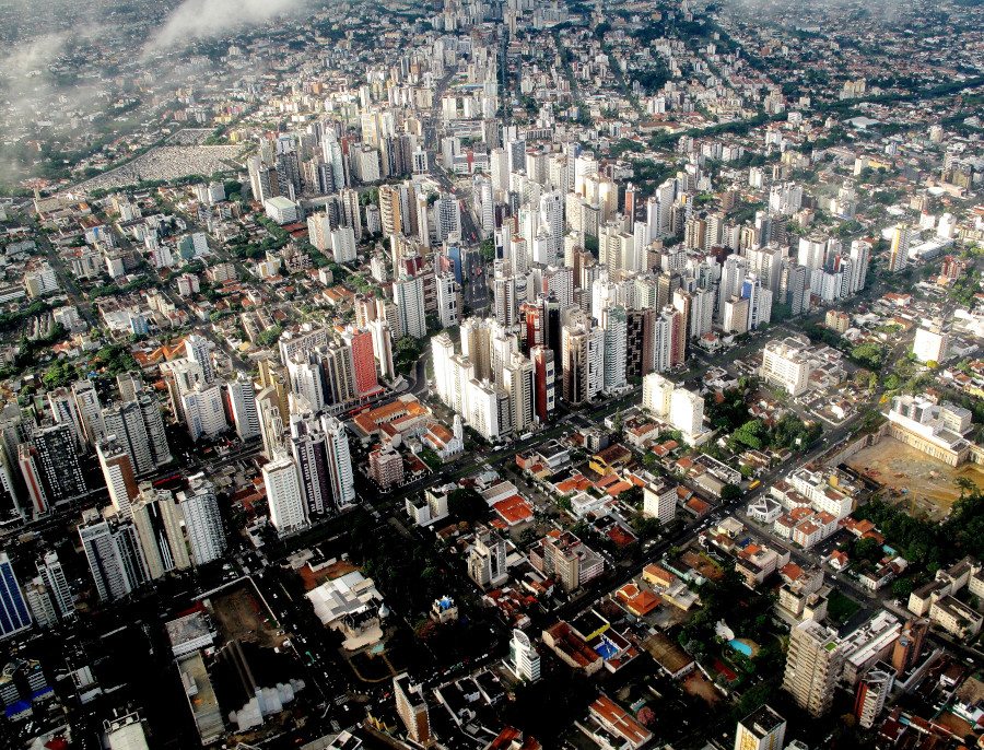
Created by the law on Grand Paris in 2010, the network of 68 stations of the GPE outlines the challenges of major development, at both metropolitan and local levels: improvement of the living environment, emergence of new centralities and the desire to rebalance the territory, the significant increase in accessibility to jobs, facilities, businesses and services.
In regional planning, the station areas are at the heart of the urban intensification strategy: densification and increased polarization around the stations in the Regional Master Plan of Île-de-France (SDRIF) and the future SDRIF-E (environmental), and the desire to create a city more favorable to active modes in mobility plans. Nonetheless, planning alone is not sufficient. The city-mobility tandem is being reconfigured and the private market, through its dynamism, is competing with public action by playing a significant role in polarization and spatial dispersion effects. All the more so as the large volume of private constructions generates a densification that increasingly weighs on the financing of public facilities or the sizing of the networks. This is already the case around certain stations of the southern section of the metro line 15, for example, in Vitry-Centre or Issy-RER, where there has been a great deal of construction in the private diffuse space.3
In Île-de-France, the environment around the stations is inserted into a heritage that is sometimes complicated to modify and where the development processes can greatly differ. In certain areas, project dynamics already existed, with public accompaniment in the production of housing (Les Ardoines, Villejuif Gustave-Roussy or Saint- Denis-Pleyel), others only present a few public projects (Châtillon-Montrouge or Arcueil-Cachan), still others accumulate a dynamic private market and public operations (Bry-Villiers-Champigny or Champigny-Centre). If we can already assess the densification undertaken in the station areas of the GPE, this has not been mastered everywhere to ensure overall coherence of projects.
Urban development around the GPE provide the opportunity to examine the TOD model. It presents numerous strong points to improve the quality of life, attractivity and coherence of these territories. It also examines the financing mechanisms through the recuperation of land and real-estate added value generated by urban development near the stations.
ASSOCIATING DENSIFICATION AND THE LIVING ENVIRONMENT
The TOD approach must not be perceived as an exclusively real-estate project guided by density. Although the minimum density threshold is around 40 housing units per hectare, it can correspond to very different urban forms such as small discontinuous multi-family dwellings or two or three-story attached houses. The idea of urban densification must be integrated into an overall project whose ambition is to offer a more desirable living environment to the resident populations. This is the case, for example, in Curitiba, in Brazil, which for a long time was a model combining densification and living environment, but has recently been caught up by a galloping demography (read example below).
Curitiba: a TOD approach incorporated into planning, having become obsolete. Curitiba long represented one of the most sustainable models in the world on urbanism-transportation coordination, with the implementation of the Bus Rapid Transit (BRT) network, accessible and heavily used, combined with urbanization of strong density and mixed use along the principal public transit corridors, while creating a very large area of green spaces (2,100 ha, equivalent to 52 m² of green spaces per inhabitant, five times more than the recommendation of the World Health Organization). If this model was able to initially meet the needs of strong demographic growth, the continuous increase in population (about +13 % between 2010 and 2016) resulted in saturating the surface network, which was however well-connected and encouraging urban extensions difficult to integrate into the city’s urban strategy. Francisco Anzola/Flickr-CC
In Île-de-France, the arrival of an infrastructure such as the GPE, which is being grafted onto an existing network and within already largely inhabited urban fabrics, raises the question: how can the inhabitants’ quality of life be improved when human density is going to increase in the station areas by the scope of the built volumes?
First by obtaining a sufficient number of nearby green spaces and by linking large urban parks through planted continuities.
Next, by placing mixed urban functions within walking distance, by favoring the quality, size and connection of public spaces both for pedestrian and cycling mobilities but also for the liveliness of the district (businesses, services and facilities). These elements are indispensable, as a complement to a structuring public transit offering that is sufficiently paced to increase its usage. But this requires the coordination of the actors, whose interests are sometimes divergent.
REGULATING THE PLACE OF THE CAR IN THE STATION AREAS
When the car retains a predominant place, a distinct improvement in the modal shift cannot be observed, and the TOD model can deviate toward a TAD (Transit-Adjacent Development).4 This is the case for the Mont-Saint-Hilaire and Sainte-Thérèse station areas in Greater Montreal and the Hayward and Fremont stations near San Francisco, deprived of nearby businesses and services and in which the built environment is mostly organized around large parking lots.
One of the prerequisites for the success of the development of a TOD-type station district is therefore to better share the uses of the road system between the different means of transportation and to limit the place of the car by increasing paid parking around the stations, reserving the parking lot-relay for nonresidents, by reducing street-level parking, largely favoring walking (pedestrian continuity, pedestrian streets) and developing intermodality with the bus and the bicycle. This strategy can be found in Singapore, where the links between land use and transportation planning are particularly strong (read example below). The precise management of the demand of passenger flows through incentive measures, in the same way als the control of road traffic with an urban toll system in real time, largely regulates the use of vehicles to the benefit of public transportation.

Singapore: close coordination between planning authorities and transportation operators. The master plan of Singapore develops the Constellation Plan concept in which the urban polarities are linked to the city center by the extension of the mass transit network. New constructions located near stations are authorized to undertake denser operations in order to maximize land use and encourage the creation of workplaces near the transportation network. If the urbanism-transportation link structures the planning document, it is the strength of the coordination of local governance that has made possible the development of new residential centralities beyond the city center, for example in Paya Lebar, the terminal of the East-West line. These developments were given particular attention in order to maintain affordable housing units and create quality green spaces around high residential density transportation hubs. The Urban Redevelopment Authority relies on a long-term development strategy and the Land Transport Authority (LTA) supervises the construction and modernization of the network, while providing a framework to stimulate the use and reliability of transportation. CharlieTong/IStockphoto.com
In Île-de-France, if the station area committees (“Comités de pôle”), established on the initiative of Île-de-France Mobilités and the Société des Grands Projets (SGP), manage the coherence of the mobility projects within a radius of 300 meters around the stations, a broadened scale including the communal, even the intercommunal, level would make it possible to ensure an efficient feeder service and greater coherence in bicycling and pedestrian continuities.
ORGANIZING AN INTEGRATED GOVERNANCE THROUGH COORDINATION TOOLS
What particularly emerges in the implementations of TODs throughout the world is the central role of local governance, associating transportation actors, developers, even the inhabitants themselves who enter the negotiation process for the development of the district. Yet, the administrative organization in the Paris region, composed of a complex system of actors in the station areas, limits this coordination. Apart from the links connecting the transportation authority to its partners in the station area committees for the organization of the “transportation” and “intermodality” functions, there are, on one hand, the local administrations, a diversity of developers, public organizations and land operators and, on the other, developers that operate in the diffuse sectors not controlled by the public authorities. This multiplicity of actors makes the action somewhat obscure and creates constraints on reaching construction objectives or for the quality of the development on the whole. In 2021, the government launched the “Vitalization of the station areas” committee to pool the dynamics or the obstacles encountered in the implementation of the projects initiated by the territorial administrations. Nevertheless, what is currently lacking is a transversal actor ensuring the coherence of the urban development around the stations through a coordination of projects on the scale of a line or a corridor.
The example of “contrats d’axe” (negotiated contracts between various partners to bring together a public transit project and territorial development) in Grenoble and Toulouse, then the development-transportation guidelines in Île-de- France, experimented on line 11 of the metro and the T9 tramway, have shown the interest in thinking on the scale of an urban corridor. This allowed bringing together all the actors around the table, including several administrative perimeters, to discuss the relationship between urban development and transportation infrastructure. However, the contrasting successes of these mechanisms show the necessity of a high coordination level upstream and downstream of a project, which remains dependent on land opportunities and is a long-range undertaking.
THE IMPORTANCE OF DIALOGUE AND THE INVOLVEMENT OF ALL THE STAKEHOLDERS
In the United States, and more generally, in the Anglo-Saxon world, TODs show, in many cases, a real involvement of local associations of inhabitants and store owners (local communities) in the implementation of projects. They are consulted in order to orient the project toward quality of life and create lively neighborhoods or, on the contrary, oppose projects, notably when densification tends to create potential pollution or gentrification. The inhabitants can also be consulted to vote on increases in property taxes necessary for financing the new local public developments. An emblematic example of TOD based on a local initiative is the Fruitvale Village neighborhood in Oakland, near San Francisco (read example below). In Île-de-France, if dialogue is developing due to social demand or regulatory obligations, its efficacy in serving the public action often remains to be demonstrated in order that all the stakeholders find an interest in it.
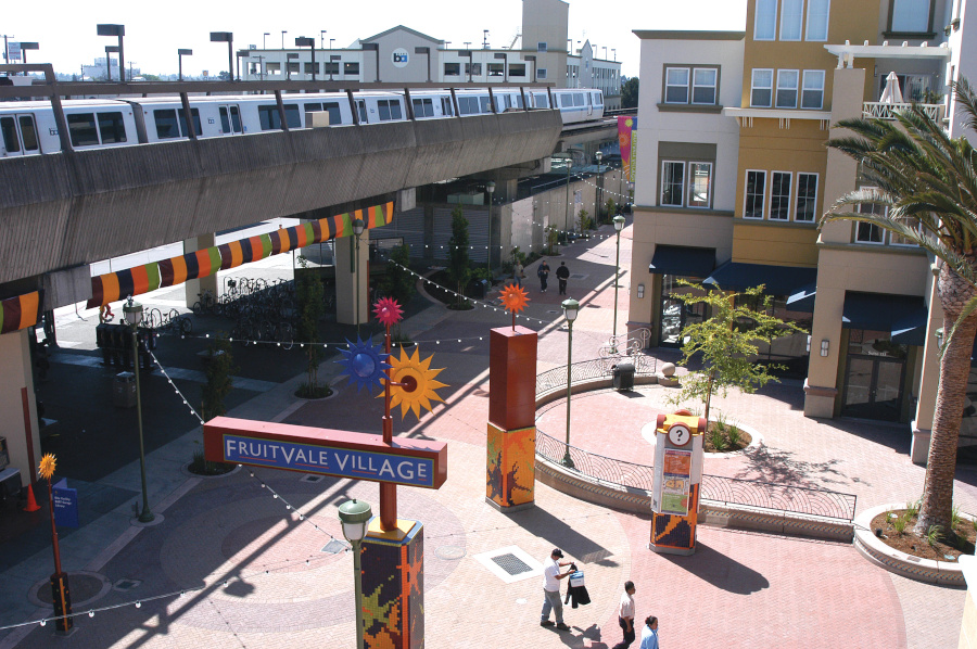
Oakland: the role of the unity council in the TOD sector of Fruitvale Village. In the early 1990s, the local population of the Hispanic district of Fruitvale opposed the construction of a large parking lotrelay near the station that the Bay Area Rapid Transit (BART) wanted to build. The local associations got together at a unity council to defend a project benefiting the residents around the railroad station. The first phase of the project, completed in 2004, made it possible to create pedestrian public spaces, businesses, affordable housing, a senior citizens center, a medical clinic, a library, a preschool and a high school. A second phase, once again dialoguing with the unity council, began in 2010, with the creation of new mixed-used islands. Although modest in size, Fruitvale Village is a successful example – and one often cited – of a TOD district, based on a strong local initiative and inserting social justice into the heart of the project. Peter Beeler, MTC
In the United Kingdom, section 106 of the Town and Country Planning Act 1990 also allows a local planning authority to negotiate with a real-estate developer on compensations that it must offer or finance in return for the future impacts of its project on the territory. The developer can consequently be bound to conclude an agreement if it wants to have a building permit. These agreements often stipulate giving financial compensation to the local authorities for the construction of infrastructures (road, school, health center, etc.). They can also include measures for the creation of social housing.
BETTER RECUPERATING ADDED VALUE THROUGH SPECIFIC TAXATION
In Île-de-France, the financing model for the construction of the GPE is based on allocated taxes,5 making it possible to provide for the reimbursement of the loans contracted. A law on the taxation of added value in the area around the stations to the benefit of the financing of the SGP had been voted in the framework of the 2010 law on Grand Paris, but it was repealed before being applied.6 If there is currently no specific taxation in the station areas, there are many examples of financing the TOD internationally using the taxation lever to recuperate added value.
We can notably mention Tax Increment Financing, widely used in the United States since the 1950s. The principle is to ensure part of the financing of an urban project by allocating the future additional revenues from property taxes (without changing the rates) in a defined sector. This amounts, for the municipalities, to freezing, for a determined duration, the amount of their resources and shifting the additional revenues from the tax to a local project. There is also Benefit-Assessment Financing, which corresponds to an additional tax on the property tax established in a defined sector and during a given period in exchange for the creation of a new urban service. It is often used to finance metro stations or lines and for public developments in the TOD neighborhoods. This is the case, for example, of the Red line in Los Angeles and the NoMa station of the Metrorail in Washington, D.C.
There are also taxes on new constructions (Impact Fees). The United Kingdom, for example, implemented the Community Infrastructure Levy (CIL), permitting local authorities to collect funds from real-estate developers that undertake new construction projects in order to finance infrastructures needed for urban development. In the case of Crossrail (Elizabeth line), a specific CIL, applying to any new construction in Greater London, was created to help finance the project.
In France, several taxation mechanisms on property, real-estate transactions and new constructions already exist (property taxes, property transfer taxes, development tax). Additional taxes or new taxes can be envisaged. Nevertheless, the potential effects on the real-estate market remain debatable when they concern a reduced perimeter: this could notably create uncertainty and a rigidification of the real-estate market, even lead to a risk of inflation. Taxation concerning a broadened perimeter seems more relevant in terms of hoped-for revenues and a limited effect on the real-estate market.7 Likewise, favoring taxation oriented toward specific financing, as is often implemented in Anglo-Saxon countries, offers the opportunity of better comprehension and acceptance from the local population concerned.
BETTER CAPTURING THE VALUE OF AVAILABLE LAND
Concerning development, one of the solutions currently used by the SGP is based on the principle of Joint Development8 through its dedicated subsidiary, SGP immobilier. Holding substantial land reserves (about 1 million m2 of buildable land area), the SGP should be the codeveloper of about a hundred real-estate and urban projects, with the objective of ensuring better mastery of environmental and social objectives, optimizing technical coordination between the station and the realestate project but also recovering part of the financial windfall generated.
Outside France, there are notably mechanisms such as the Development Rights Auction making it possible to recover part of the added value generated by the developers. In Copenhagen, for example, the construction of metro lines 1 and 2 was partially reimbursed by the sale of land to private developers. This land, initially held by the federal government and the city, which became attractive with the arrival of the metro, permitted the concurrent development of the new TOD district of Ørestad. In Hong Kong, the Mass Transit Railway sells buildable land, initially recovered at an advantageous price from the government (read example below). In Brazil, certain municipalities have recourse to Certificates of Additional Construction Potential (CEPAC). This is also a Development Rights Auction system enabling the densification and revitalization of certain areas (read example below).

Hong Kong: the Rail + Property model. MTR, the Hong Kong railroad operator, uses the Rail + Property model to finance the construction and operation of metro lines. MTR initially bought, at a preferential price, the land to be built from the government then put it up for auction at a premium price including the effect of the arrival of the metro in the zone. MTR also recuperates part of the added value resulting from the sale of building rights, recovering part of the benefits of the private developers generated by the buildings sold or rented (businesses, offices or housing). MTR also recovers the buildings that had not been sold or rented within the times stipulated in the contract and obtains their ownership. It is consequently free to sell or rent these buildings itself. At the same time, MTR is also the owner of the stations on its network and the shopping centers from whose management it draws revenue. Diego Delso, delso.photo, License CC-BY-SA
Brazil: Certificates of Additional Construction Potential (CEPAC). Since 2001, Brazil’s municipalities have had the possibility of modifying the Urbanism Code in order to create and auction building rights (CEPAC) with the developers. The idea is to collect private funds to finance public investments necessary for the revitalization of certain, often disadvantaged, areas. The establishment of CEPAC requires the prior existence of an urbanism plan and the creation of a “Joint Urban Operation.” This entity, coordinated by the municipality, brings together the stakeholders of the CEPACs’ zone (inhabitants, public and private actors). Its aim is to provide structural urban modifications and social and environmental improvements to the district. Modifications can notably be made to land use and building standards. Transportation infrastructures can also be included in these operations. To be noted: the financial resources obtained through the sale of CEPAC are exclusively used for the Joint Urban Operation. Pedro/Adobe Stock.com
The better regulation of conditions for obtaining development rights on the private market for more coherence of the projects, as well as a better recovery of the added value generated by the developers, remains an important subject to be examined for the station areas in the Paris region.
A TRANSVERSAL ACTOR TO GUARANTEE THE COHERENCE OF URBAN PROJECTS
The local socio-political context and territorial governance play a decisive role in the implementation of TOD projects. To succeed, the development of station areas must first of all combine the different ingredients of the model linked to regulations on land use. Other organizational factors are to be considered, such as the synergies that are created between developers (planning and transportation authorities) and with all the stakeholders, including the inhabitants of an existing or future district. The significant driving role that a transversal actor can play to trigger an urban dynamic, the liveliness and quality of life of the district, could transcend the approaches compartmentalized by a complex governance or the multitude of standards. In addition, the content of the urban project must be welldefined and shared between all the actors that wish to develop it. In Île-de-France, apart from the central role played by the SGP, which handles the construction of the metro and a minor part of the real-estate projects in the station areas, a coordinator of urban projects on the scale of corridors or lines could further ensure the coordination, implementation and global view of the development oriented toward public transportation.■
1. North American movement founded to limit urban sprawl and favor density, the quality of public spaces and walking.
2. Smart Growth originated in the urbanization management theories of the 1960s and evolved toward its current form in the wave of the sustainable development paradigm in the late 1980s.
3. Diffuse space: urban space located on small plots, generally under 5,000 m² and that are not the object of an overall project directed by the public sector.
4. Concept developed by John Luciano Renne, in which urban development gives a predominant place to the car.
5. We find as taxes allocated to the GPE a supplement to the tourist tax, the tax on office space, the flat-rate tax on network businesses (IFER) and a supplement to the special tax for public land establishments.
6. This flat-rate tax was to concern the product of the development of unbuilt land and buildings constructed in a perimeter up to 1,200 meters from the entrance of the passenger stations.
7. “Valorisation foncière et financement des infrastructures de transport,” Note rapide no. 477, L’Institut Paris Region, 2009.
8. Cooperation agreement between a public organization and developers/private owners to build mixed-use development projects, generally on the large scale, on land held by the public organization.
further reading
Calthorpe, P., The Next American Metropolis, New York: Princeton Architectural Press, 1993.
This study is linked to the following themes :
Mobility |
Urban planning
