Assessing the new challenges of China's metropolitanism: the case of Xi'an
China has adopted “ecological civilization” as a formal state policy, and a reform of the spatial planning system launched in 2018 was part of it. New guidelines are proposed to assess existing plans and challenges nationwide, and Xi'an developed with specific objectives and indicators compatible with the city. Both the conclusion and database of this assessment will impact the new master plan in preparation. The Institut Paris Region is keen to compare metholodogies for the monitoring of master plans of megacities.
Located in the northwestern region of China, belonging to the Yellow River Basin, Xi’an, historically Chang’an city (one of the four ancient great capitals of China) now has a similar population and surface area to the Paris region. The assessment of the status of territorial protection, development and utilization is not only to compare to the past planning methods, but also to meet the new challenges in the future. At this point of time, Paris’s challenges and solutions can provide inspiration to Xi’an. Xi’an became a “Gamma” city* in 2016, according to the Globalization and World Cities Research Network (GaWC, 2019), due to increasing linkage with the world. The Xi’an metropolitan area is among the nineteen prioritized city clusters in national plans. The size of the Xi’an metropolis continues to grow, and the projected annual rate of population growth will be 1% to 3% over the next 15 years and then gradually stabilize. However, environment concerns are becoming crucial for Xian’s development: water resource is scarce (less than 245 cubic meters/inhabitant); the Qinling Mountains cover 50% of the area which has been listed as a “Priority Area for Biodiversity Protection in China”.
NEW IDEAS FOR CHINA’S URBANISM: RECOGNITION OF METROPOLITANISM
In response to the excessive consumption of natural resources, severe environmental pollution, as well as the problem of ecosystem degradation, in 2012 the Central Committee of the Communist Party of China decided to promote “Ecological Civilization”, a policy framework that prioritizes ecology. In 2015, the State Council announced the institutional reform plan, which proposed to establish “a new spatial planning system” as one of eight measures to solve the problems. Major concerns include the consumption of cultivated land and natural spaces, inefficient development and the integration of the current overlapping spatial planning system. China’s overall urbanization policy for the past decades has been described as “keeping the growth of large cities under control and actively developing medium and small-sized cities and towns”. Nevertheless, China’s New Urbanization Plan (2014) proposed to take city clusters as the main carrier of future urbanization. The decision recognized, on the one hand, the success of coastal metropolises in terms of boosting the economy and global integration, and on the other hand, the lower capacity of the mid-west regions with more polarized cities or metropolises to ease the stress and preserve natural spaces of ecological importance. Among all the policy instruments, the household registration system (“hukou”) plays a key role in checking urbanization, in spite of control difficulties. However, annual implementation of the New Urbanization Plan in 2019 took steps to encourage population growth in megacities and metropolises of less than 5 million inhabitants liberated from the restrictions of the registration system. Also, a recent meeting held by the Central Financial and Economic Committee emphasized the need to strengthen the economy and population capacity of advantaged areas such as metropolises and city clusters. But, at the same time, land policy is less generous accordingly, due to the still prominent issues of urban sprawl and consumption of natural spaces. Nevertheless, spatial planning system reform objectives include the transformation of land policies from land-use scale indicators to urban growth boundaries (UGBs), in order to foster a more efficient and qualified land-use model.
THE CURRENT SPATIAL PLANNING SYSTEM IN XI’AN
There were two spatial planning systems led by different authorities in China before. According to the Law of Urban and Rural Planning, the government of a city shall establish overall plans for filing construction approval, and also zoning plans for land use regulation, as required by the Law of Land Administration. Accordingly, Xi’an has two strategic spatial plans on the scale of 10,000: the urban master plan for a continuous urban area (2008) and the general zoning plan of the municipal region (2013). Planning systems also include detailed regulatory and sectorial plans, including transport, housing, sewage, etc. All documents expired in 2020, and the filing, examination and approval of the strategic spatial plans are due to be integrated, as proposed by the reform. The scope of the new plan will be the municipal area, and the contents will cover the original plans and the supplementary areas of ecological protection and restoration. Since 2012, the economic, social and policy environment has undergone major changes unforeseen by the original plans. Several concerns involve the transformation of economic structure and the deceleration in urbanization process, as well as the decrease of the tolerance thresholds of ecological damage on both parts of the government and the public with the improvement in citizens’ quality of life. Meanwhile, the Paris Region master plan was approved in 2013, after more than 10 years of collective design involving numerous planning stakeholders. The ‘Sdrif’, as it is also called, is a long-term strategic planning document on a regional scale issued by the Regional Council in association with the State, which guarantees its implementation. The master plan’s purpose is to keep demographic and urban growth under control and master the use of space, while preserving the international influence of the region. It introduces quantitative objectives and normative provisions, which must be considered in local planning documents. Unlike Xi’an, the Paris region has undergone much less structural change recently and its master plan is still very relevant. But the swift increase in environmental concerns implies close monitoring of its effects, thanks to specific indicators.
INDICATORS FOR MONITORING OBJECTIVES AT CITY LEVEL
The Bureau of National Spatial Planning within the Ministry of Natural Resources in China has proposed “Technical Guidelines for the Evaluation of the Status of Spatial Development and Protection”, to encourage individual cities to establish compatible indicator systems based on measures of safety, innovation, coordination, sustainability, opening-up and inclusion, and also to find gaps to adapt to the new ideas and policies of the central government. The evaluation system focuses on governance, ensuring that the indicators can be traced, the calculation method can be queried and subsequent monitoring can be performed. Hence, the selection and reporting of indicators are organized by the Xi’an Bureau of Natural Resources and Planning (NRP), and data are stored and coordinated by the NRP’s information centre. Data and documents are provided by government members, including the Bureau of Statistics, the Construction Commission, the Development and Reform Commission, the Industry and Information Commission, and various other Bureaus. In conclusion, 25 evaluation fields and 95 indicators have been identified as the outcomes of the database. All indicators are supposed to present features of Xi’an and cover priority aspects of this spatial planning reform. Unlike earlier evaluations of Xi’an, this one is not only about the identification of the differences between goals and results achieved, but it also aims to establish a zero point for the new plan with a database, as it was done with the Sdrif 2030 master plan. Analysis of status and trends is based on the database, which will be updated by subsequent annual monitoring. New techniques, such as big data, are encouraged to be integrated into the method and are expected to be institutionalized in the future. The evaluation of the Paris Region master plan has been conducted by L’Institut Paris Region, in association with the Region’s different departments. It questioned the impacts and ambitions of the master plan according to different scales and the timescale of the project. The evaluation relied on about 70 indicators to measure the efficiency of 36 regional objectives, the zero point being the date of approval of the plan, i.e. 2013. In addition to the indicators, a strict analysis of the consistency of Sdrif regional planning with local planning (PLU) has been conducted. The linkage between the policies and actions of the relevant stakeholders with the main goals of the master plan has also been analysed.
ANALYSIS AND ASSESSMENT
Safety: to adhere to the baseline
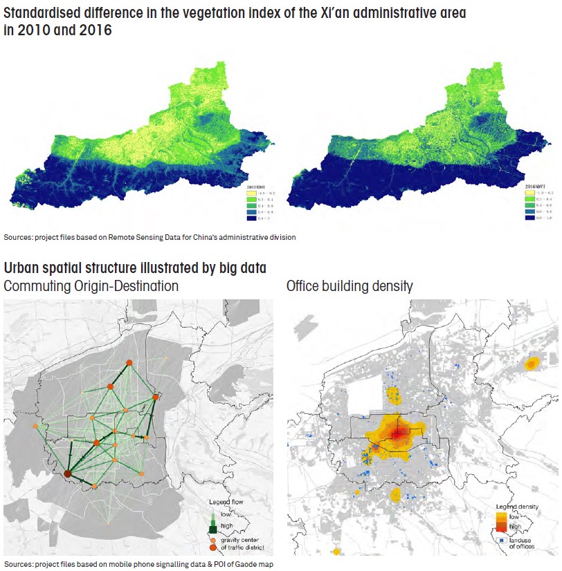
In Xi’an, the baseline involves mandatory indicators including cultivated land area, nature reserve area, construction land area, water consumption, etc. Xi’an is located in the main grain production zone of the Fenwei Plain. Despite the fact that the grain self-sufficiency rate was 96% in 2018, the total area of cultivated land consumption rose to 14,134 hectares due to construction site occupation over the past five years (in the Paris region, 2,900 hectares of urbanization has occurred over the past five years). In the meantime, the planting area of vegetables and fruits continues to increase, while grain surface areas have declined accordingly. Also, the utilization rate of local water resources development in Xi’an has risen to 76%. As a result, there has been a general shortage of ecological base flow and multiple substandard monitoring river sections. Remote sensing data indicates that nature reserves are well protected and the surface area of forest continues to increase. This evaluation reflects the impact of urbanization on ecology, agriculture and culture.
Innovation: to measure the dynamics of economic activities spatially
Xi’an is an important city for innovation in China, with technology output/turnover ranking second only to Beijing’s. The city’s research and experimental development expenditure has remained above 5% in terms of GDP over the last five years. The proportion of industrial land in the continuous urbanized areas dropped from 17.4% in 2007 to 10.6% in 2018, reflecting the spatial impact of deindustrialization. One of the main conclusions of the evaluation is that newly supplied industrial land on the periphery cannot meet the needs for proximity of innovation and production. Although different, Xi’an’s situation presents some similarities with the Paris region’s situation. As emphasized in the 2018 evaluation, industrial and logistics areas tend to be reduced in urban areas, but they are major factors of urban sprawl in suburban areas.
Balanced-growth: to examine the emergence of new city centres
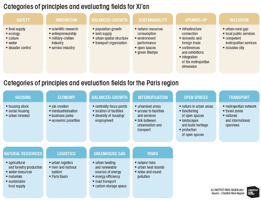
Between 2010 and 2018, although increases in number varied, new residents in Xi’an reached 250,000 per year (50,000 per year in the Paris region) due to a competitive population policy. In terms of land use, newly added urbanized areas in the same period amounted to 2,701 hectares, close to the rate of population growth (five times more than in the Paris region). However, the overall ratio of new construction land to renewal land is 5.6:1, indicating that the urbanized area has been spreading outward. Big data can be an efficient tool for visualizing urban spatial structures. The analysis shows that new city centres are emerging with the expansion of city areas, which has clearly deviated from the original plan. Congestion is more common because of the growing incompatibility between the capacity of the transportation system and the significant increase in the volume of construction work. At the same time, the old city (equivalent to the size of the city of Paris) has been experiencing a decline due to population and industrial outflows. In the Paris region, the master plan has adopted similar evaluation approaches to examining the coordination of urban development. The analysis helps to monitor the location of new inhabitants and new jobs and assess their effects on regional balances. Using the regional land-use occupation tool has made it possible to analyse the ratio of urban renewal in the urbanization process (1:1 for residential land).
Sustainability: to monitor natural resource consumption and the environment
Monitoring indicators of natural resource consumption include water utilization per GDP and per irrigation; the percentage of recycled water; energy consumption per GDP; the percentage of clean energy heating; and the percentage of recycled domestic waste. Environment performance indicators examine data that combine the discharge of major pollutants, environmental function zones and the quality of open spaces, including the surface area of urban and suburban parks and the length of greenways. Resource utilization and environmental quality enhancement have generally been improving. But there is a lack of coherence between the insufficient green spaces in the central city and the regional locations of ecological assets. This is also very true of the Paris region.
Open-up: to evaluate city networks worldwide and in proximity
Xi’an is the starting point of the ancient Silk Road and an important transportation hub in China today. Since 2018, by high-speed rail, travellers from Xi’an can reach 128 cities above prefecture level, and the Xi’an’s International Container Port was ranked in 1st place within China’s hinterland in 2018 in terms of heavy load rate, freight volume and actual traffic volume. Also, air cargo via Xi’an International Airport ranks 13th in the country. Xi’an has become a major destination for hosting international conferences and events, such as the Eurasian Economic Forum, the Global Hard Technology Innovation Conference and the Silk Road International Film Festival, which ranks 4th in China after Beijing, Shanghai and Hangzhou. Analysis shows a significant increase in connectivity with other world cities, especially with first-tier cities in China such as Beijing, Shanghai, Shenzhen and Chengdu. The volume of corporate headquarters and branches has increased rapidly, and the total amount of inward foreign investment has already exceeded the internal levels of city clusters, also reflecting the low level of urban integration around Xi’an and the lack of industrial gradient division.
Inclusion to enhance attractiveness and happiness
Xi’an has a younger population and a higher quality of cultural life compared to most cities in China, while professional and technical personnel account for 23.6% of the total employed population. Xi’an ranks 9th in the “2019 China City Business Charm Rankings” released by China Business News, which indicates the quality of metropolitan services. As for public services in the city, more than 60% of the residential communities have inadequate facilities that do not meet national standards. The proportion of social housing is only 10.9% (whereas it represents 24% in the Paris region). There is an obvious gap between the supply of and demand for housing and education facilities in specific areas where the number of new residents is booming. Besides, the urban-rural gap is still large, despite the relatively large urban population in Xi’an (74%). Unlike urban areas, the lack of tap water and of sewerage remain major restrictions on the living standards of villages.
CONCLUSIONS AND PROSPECTS
While most metropolises in China are more successful than expected in term of efficiency, they endure more severe ecological and environmental issues as well [WANG Kai, CHEN Ming, 2018]. Emerging new metropolises in China are restructuring the country during the rapid urbanization progress, however they often possess low levels of natural resources per capita or close to areas of ecologically importance and sensitiveness. For Xi’an, the prioritized challenge for the next 15 years is to reconcile the coexistence of high-density urbanized areas with natural spaces. It is necessary to avoid the problems that have repeatedly occurred in the past, such as an imbalanced spatial structure and its consequences, and to improve mixed land use to enhance innovative industries. Xi’an city managers must also look into the entire ecological and agricultural space, and actively respond to the issue of ecological continuity in metropolitan areas and the comprehensive use of rural areas other than for agriculture, especially to rescue villages and their heritages. Evaluations have highlighted the dynamics of population and economic activities in metropolitan areas, and big data monitoring has proved an effective method to study spatial distribution. In the past, the Paris region successfully guided the development of new cities in metropolitan areas, and consistently conducted effective protection of historical sites and natural areas. Today, the focus is on social inclusion issues, i.e. housing and public facilities, aimed at actively adapting to/mitigating the impact of climate change and at fostering the innovation economy. The three challenges identified in Paris in 2013 are still clear-cut and the Sdrif regional plan formulated accordingly has been effectively implemented. In terms of content evaluation, the Paris region has paid more attention to the policies and actions of relevant stakeholders than to government sectors compared to Xi’an. Thus, a very careful verification of the consistency of the Sdrif master plan with local plans (PLU) has been conducted, which will inspire the future monitoring and evaluation work to be done on Xi’an.■
This study is linked to the following themes :
International |
Urban planning
