The MOS, in a few words
For 30 years, the MOS (mode d’occupation du sol), Île-de-France’s Land Use Map, has been essential in underpinning public planning policies in the Region. How is it produced? What purpose does it serve? Here is an overview of how it is made, how it is used, and what its limits are. Beyond the mechanics of the MOS tool itself, we should not lose sight of how important monitoring of land use is in planning policies, both for making plans and schedules, and also for prevention, preservation, or indeed measurement and assessment.
Making the MOS
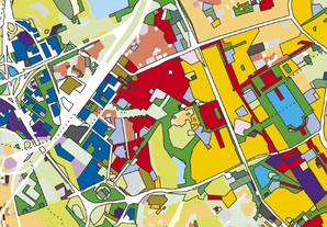
Knowing the region’s territory and how it is changing is a concept that started being used in L'Institut Paris Region as early as 1965, leading to a first atlas being produced in 1976 on the conurbation of the territory of Paris Region. In 1982, a digital land use map was produced and, for the first time and homogeneously, it covered the entire Île-de-France region. Regularly updated every four or five years, the latest version (2012) is the eighth campaign of this land use inventory. Every update starts with an aerial photo being produced, the characteristics of the photo having changed over time . The shots are assembled together after their geometrical deformations have been corrected and after their colours have been harmonised. The photo interpretation complies with precise specifications that guarantee the quality of the work done. The MOS is superposed on the aerial photo: each operator systematically scans the territory he or she is covering using the additional data supplied by L'Institut Paris Region and the images from the preceding campaigns.
Over this 30-year period, the tool has been adapted to accommodate technical changes, thereby guaranteeing that the various version of the MOS are mutually compatible. With the nomenclature of the 2012 edition being transformed into a national standard that is in the process of being developed, it will henceforth be possible to produce farmland, woodland and natural space consumption indicators that are common to other French regions or to other countries who use comparable nomenclatures.
Making plans and schedules

In the context of spatial planning, this monitoring of land use can be performed at various scales (nation, regional, and local), and makes it possible to monitor attainment of a variety of objectives, from planning to operational implementation.
For instance, since the 1960s, Norway has been using a cartographic tool that monitors national land use for optimizing its spatial strategy for allocating land, and in particular use of farmland. Containing the necessary information, that geolocation database currently serves as a basis for calculating and for allocating farming subsidies. In France, an approach for monitoring land use on a large scale is currently being developed (by the Céréma, Center for expertise on risks, environment, mobility and planning). It will make it possible to homogenise the approaches and tools, opening up the possibility of making comparisons between regions, and indeed comparisons with other European countries.
At regional level, monitoring of land use can be used as a basis for futures studies. It can be the cartographic basis for a spatial project, as it is in Île-de-France. Thus the Land Use Map (MOS) is one of the Île-de-France planning aids, enabling planning to be economical with space. In addition, by being regularly updated, it will make a major contribution to monitoring and assessing the Region’s Planning and Development Master Plan (SDRIF) up until 2030. Monitoring of land use is also used in a futures study perspective by other urban planning agencies, e.g. in the context of creating SCOTs (schemes for territorially consistent planning and development), as applies for the Lyon-Metropolis area.
At local level, monitoring land use can be an aid for more operational studies. Thus, associated with other data, the EpaMarne (Marne public planning body), together with the design office Biotope, use the MOS for determining the biodiversity issues in local urban projects. That analysis has led to recommendations being drawn up for project managers of the relevant urban planning operations.
The MOS on-line and in practice
The IAU website proposes on-line tools for consulting, interrogation, and analysis, including the latest update of the MOS, its 2012 edition (www.iau-idf.fr/cartes/mode-doccupation-du-sol-mos.html). Among those tools is a knowledge base on the MOS, an interactive metadata repository of land use in its most detailed version, in 81 items. The application makes it possible to locate places within a municipality, and to identify the items by using an interactive tool that enables the user to understand to what the nomenclature corresponds and to obtain a precise definition of each item in the MOS: www.iau-idf.fr/cartes/base-de-connaissance/mos.html.
Prevention and preservation
As regards prevention, the MOS (Land Use Map) and its theme-based versions (Evolumos, Densimos, Densibati) make it possible for zones vulnerable to risks to estimate the corresponding surface areas and populations. It is then possible to measure the human, economic, and environmental stakes and issues of such exposures to risks, and thus to work to prevent them.
In practice, this translates in different ways. For example, the IAU îdF produced, for GRTgaz (French gaz provider), work analyzing the human stakes and issues in the danger areas related to its gas pipe network. That work led to compensatory measures being implemented aimed at dealing with any non-conformity with the rules, and to specific protective measures being put in place.
As regards flooding and its consequences, use of the MOS and of its theme-based versions makes it possible to characterize the populations and property exposed to the various hazards within a given territory. As early as 2000, the MOS thus revealed the importance of the urban issues and stakes in the exposed zones of Paris Region. Today more precise modelling is making it possible to estimate the cost of damage depending on various flood scenarios. Disseminating such information constitutes a key part of risk prevention policies.
In terms of preserving and enhancing natural environments, Ecomos 2000 and its 2008 update give a cartographic database of Paris region’s natural environments, and that tool has become an essential instrument of knowledge and analysis. It has many uses among which are: documents for informing local authorities of national regulations; impact studies; or wetland studies related to the French law on water.
In conjunction with Ecomos and Ecoline, the MOS is also used in identifying ecological continuities and biodiversity reserves. Such work then makes it possible to draw up recommendations in the context of planning and development operations. There are various clients for this type of analysis: public planning and development bodies, local authorities, or even the Société du Grand Paris (SGP, the Greater Paris Corporation). However, for such biodiversity studies, the frequency of the updates remains too low and requires additional surveys.
Measuring and assessing consumption of space

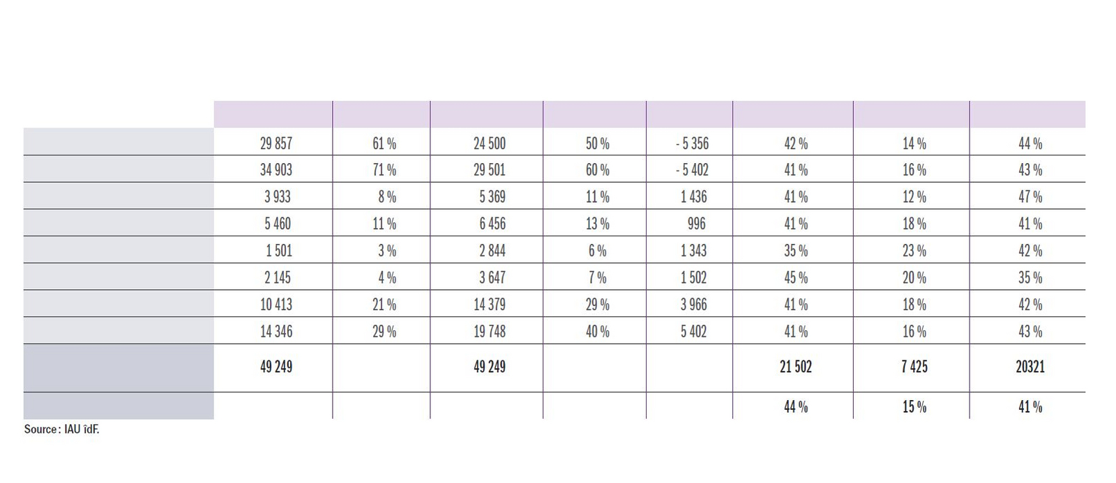
Keeping urban development under control and monitoring consumption of farmland, woodland, and natural spaces constitute essential issues in planning. Therefore, it was not by chance that the first thoughts on monitoring land use emerged in the early 1960s, while the 1965 Paris Region Master Plan was being drawn up. In 1982, the first exhaustive inventory of regional land use was taken using a method that enabled it to be compared with future updates. As of being designed, the MOS was thought through as a database making it possible to quantify and to locate the consumption of spaces. Its latest version shows a marked reduction in the consumption of farmland, woodland, and natural spaces from 2008 to 2012.
Beyond the borders of Paris region, monitoring the consumption of spaces is often a decisive objective in implementing tools for monitoring land use. The development of this geographical information uses various techniques (satellite imaging, aerial photographs, tax data, etc.), in order to meet the challenges specific to each local area or territory. In South Africa, the region of Gauteng, which includes Johannesburg, has deployed a system of monitoring land use in addition to the land registry data and that, on the basis of satellite images, makes it possible to monitor the consumption of spaces by the spread of informal housing, which is spreading particularly quickly in the rural areas. In Australia, the State of Victoria is using semi-automatic interpretation of satellite for increasing the frequency of monitoring of farmland and, in particular, for better understanding the damage caused by fires.
In France, Environmental Laws “Grenelle 1” and “Grenelle 2” reassert the importance of limiting urban spread and urban sprawl, while the law n modernization of framing and fishing has set a target of halving the loss of farmland surface areas by 2020. Although certain territories, like the Nord-Pas-de-Calais region or the Provence-Alpes-Côtes d’Azur region, who are particularly urbanized and faced with major urban sprawl, developed regional tools for monitoring land use as early as the 1990s; other areas, in particular territories with SCOTs (schemes for territorially consistent planning and development), are starting to create observatories of land use in order to meet those new legal requirements. The urban planning agency of Caen-Metropolis is thus producing a monitoring tool that aims to publish a layer relating to land use dated 2009, but also, a posteriori, a layer dating from 2000.
And in the future?
Faced with the legar requirement of measuring the consumption of spaces, the IGN (France’s National Geographical Institute) has the task of constituting a national database on land use. One of the challenges thus lies in generalizing and disseminating this information. Prior to that, it is necessary to make the various existing monitoring tools consistent with one another in order to facilitate national or even European comparisons.
The international examples also show the utility of crossing databases. Tax data would make it possible to improve description of the land use: densities, variety/mix, and renewal of urban fabric could also be better understood. By submitting its land use to oversight from the local authority spatial planning body and then to the local councilors, the urban planning agency of Caen is opening up a new avenue to be explored: the possibility of participative monitoring of land use.
1. This summary article uses the articles of issue no.168 of Les Cahiers entitled MOS 1982-2012 – volume 1 Du ciel à la carte (MOS 1982-2012 –volume 1 : from the sky to the map).
2. Since the 1999 update, the photographs that are taken are orthorectified so as to be transformed into orthophotographs.