More and more cycle routes in the Île-de-France region
The introduction of cycle routes in the Paris region has risen steadily since 2010, with over 3,500km of cycle ways in use today; the result of local and regional policies encouraging bicycle use. The region’s grande couronne (outer ring) is also catching up to central Paris; 35-45% of these cycle routes are located within the planned Grand Paris metropolitan area.

With 3,532 km of cycle routes registered at the end of 2012, cycle networks in the Paris region are continuing to swell. They grew by 61% between 2007 and 2012, not far off the 67% average rate observed in France as a whole over the same period(1).
Between 1999 and 2012, the cycle route network in Île-de-France tripled from 1,375km to 3,532km (+157%). Districts at the heart of the urban area (Paris and adjacent zones) provided the greatest impetus, developing their networks most significantly: cycle routes have grown by 300% in Paris itself, from 129km in 1999 to 545km in 2012. Over the same period, cycle routes in the districts of Hauts-de-Seine were extended from 58km to 253km.
The extension of demarcated cycle paths has been accompanied by an overall rise in the popularity of cycling; residents in and around the Paris region are biking more than they did ten years ago. According to the Comprehensive Transportation Survey (EGT), bike journeys in Île-de-France rose from 300,000 per day in 2001 to 650,000 per day in 2010. This trend is true of all active modes of transport, with walking also seeing a rise in popularity.
Most cycle paths found within the central urban area

At the end of 2012, the extent of demarcated cycle paths(2) in the Île-de-France region had reached 3,532 km: 1,282 km in Paris and neighbouring districts (the so-called petite couronne or inner ring) and 2,245km across the outer ring or grande couronne (see table). In total, 593 districts have cycle paths along their public roadways, which is around half of the total districts in the region.
Since 2000, public development policies have led to a concentration of cycle path introduction in the urban areas, specifically in the 138 districts at the heart of the metropolitan area. In addition, 80 % of demarcated cycle routes (2,832 km) are found in built up areas or the central metropolitan area, where most districts benefit from dedicated cycling facilities. 701km of cycle lanes are overseen by 26% of the districts located within peri-urban and rural areas (223 districts). Moreover, districts closest to the centre of the metropolitan area show a higher density of demarcated cycle paths, with over 9km per district on average. The further one goes from the central urban area, the sparser cycle routes become. The average extent of cycle paths per district is 2.7 km (see diagram 1).

The Grand Paris Metropolitan area (MGP) is a new administrative entity due to come into existence on January 1st 2016. Its initial perimeter, as defined under the Maptam law, adopted by Parliament on December 19th 2013, covers (at least) the 124 districts of the Hauts-de-Seine, Seine-Saint-Denis and Val-de-Marne areas, as well as Paris itself. These areas combined possess 1,282km of cycle paths, which is about a third of the total number for the region.
The secondary perimeter, which includes 46 adjacent districts, may eventually be absorbed into the MGP, forming a maximum coalition of 171 districts - in this instance, the MGP would possess 1,643km of existing cycle paths, or 46% of the regional total.
About the study
Since 1999, L'Institut Paris Region has been paying close attention to the development of cycle networks across the Île-de-France region. The last region-wide study was carried out in 2007. In 2012, a new inquiry led by the Île-de-France regional government and L'Institut Paris Region, and carried out across the 1,281 districts, 115 councils and 8 general councils, provided fresh data, a more refined information stream and the introduction of a new category of cycle route: one-way roads with contraflow lanes for bicycles. Cycle path development data was updated for 300 communes and 23 councils (a response rate of 23%), and the results were extrapolated across all areas where cycle route developments has been ongoing for 13 or more years (593 districts).
"Grande couronne" catching up
")
Every year since 1999, an average of 166km of new cycle paths have been installed across the Île-de-France region. Between 2007 and 2012, the pace of development has accelerated to 268km per year.
However, these average figures hide geographical disparities. Between 1999 and 2007, the city of Paris boosted overall growth, averaging 21km/year of new lanes. Other areas installed between 10 and 14km per year, and slightly less in Val-d’Oise.
Since 2007, the increased pace of cycle path development has been especially notable in the region's "outer ring" (grande couronne).
The Seine-et-Marne and Yvelines areas have been the most active, averaging 48 km and 47 km of new lanes/year between 2007 and 2012. Paris and the Essonne area have sustained a steady development rhythm of around 40km of paths opened per year.
Other areas are moving more slowly, but in a positive direction nonetheless: Hauts-de-Seine and Val-de-Marne have raised their numbers to 13km/year and 16km/year respectively. Val-d’Oise is beginning to catch up with neighbouring areas, reaching an average pace of 12km/year, up from 5km/year over the period of the previous study.
Only in the Seine-Saint-Denis area has development slowed, from 10km/year to 5km/year.
This overall acceleration in development is the result of local council policies (districts, councils and departments) encouraging bike use, supported by policies from the regional government.
Districts in the Île-de-France region with the most bike-friendly development efforts
Of the 593 districts in the Île-de-France region that have cycle paths as part of their public roadways, 85 (excluding Paris) have what are termed "substantial" cycle routes (10km or longer). They represent 6% of all districts in the Île-de-France region and 14% of those with cycle paths.
Cycle paths on roadways are not the only tools available to authorities hoping to make areas more bike-friendly. Management of public spaces and speed moderation measures can make regular roadways safer for cyclists; traffic-calming measures such as "30 Zones" (equivalent to a 20mph zone), “pedestrian-priority” zones (zones de rencontre) and pedestrianized streets can often serve to effectively link and complete a cycle route network.
To the aforementioned 85 districts we may therefore add those districts whose councils have elected to introduce widespread “30 Zones”, which may in fact lead to the complete disappearance of newly demarcated cycle paths in those areas in years to come. 19 districts in the region are currently classed as "Villes 30" (20mph Towns)(3).
The districts that have adopted the most bike-friendly developments tend to be those that function as infrastructural clusters, in terms of urban density, services, business, tourism or administration. All areas classed as town/prefectures (excluding Saint-Denis, which has strict constraints in terms of traffic and parking) fall into this category, as do a large number of sub-prefectures. Two districts are exceptions to this pattern, with 14km of cycle lanes (without any specific polarity, in rural areas): Champcueil (91) and Charny (77). A district's centrality is therefore a significant factor in whether or local authorities are likely to adopt pro-bike policies.
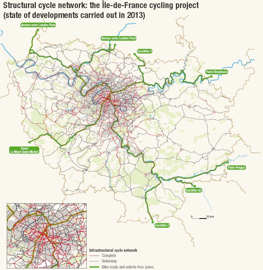
In 2010, 750km of cycle routes were part of the cycling infrastructure in the region, which has aimed to create 4,400km of interconnected routes. Work on the scheme has gained pace with the development of a number of new segments totalling 1,500km of routes as of the beginning of 2013, or one third of the total regional network. This acceleration is the result of a regional policy expressed via the PDUIF and the Plan Velo (Bike Plan), both of which encourage local councils to extend cycle networks and reduce speed and traffic on their roads. Encouraged by the regional policy and in order to establish an uninterrupted cycle route network, districts have laid out cycle paths as part of the infrastructural cycle network (réseau cyclable structurant, or RCS), which represents a significant portion of total developments: 1,500km out of a total 3,532km, or 42% (with other routes having been developed outside the RCS). Three areas in particular have concentrated development work on priority routes as defined by the regional government: Val-d’Oise, with 77% of cycle routes laid out within the RCS, (214km of a total 278km), as well as Val-de-Marne and Seine-Saint-Denis with 53%. The instigation of the Sdic and other regional schemes arising as a result of general council policy have contributed significantly to the development of the RCS. In particular, Paris and Val-de-Marne have established over half of the cycle network goals outlined by the region. In Paris, only 44km remains to be completed (20%), and 148km in Val-de-Marne (47%). Conversely, only 20% of RCS pathways are in operation in Seine-et-Marne, which means over 1,000km are yet to be completed. However, the general council and districts have taken this network into account; the 265km of RCS routes in the district equates to 40% of total development (661km of cycle routes). Included within RCS planning are the sections of the five national bike roads and vehicle-free pathways that pass through the region. The site assessment carried out in 2010 by the National Observatory for Cycle Routes and Vehicle-Free Paths (ON3V) showed that the Île-de-France region was one of the least developed in France. Of 528km of registered networks, only 17% have been marked out. The Île-de-France regional government is the unifying authority behind these various initiatives, and aims to become an active and major interlocutor for the development of bike roads and vehicle-free routes. To this end, a regional cycle route plan has been laid out, which aims to create, by 2020, in 2013 became the project leader for the only European cycle route that passes through the region: EuroVélo no. 3, a 5,122km route stretching from Trondheim (Norway) to Saint-Jacques-de-Compostelle (Spain).
Diversification of types of developments

Changes in the type of equipment used to create cycle routes are also being observed. Though they remain the most popular choice, cycle lanes and paths are losing ground to mixed thoroughfares, vehicle-free routes and low-traffic roads. Cycle paths and lanes represented 73.5% of cycling routes laid out in 2007, compared to 53% today, whereas the portion of mixed thoroughfares and vehicle-free zones has risen from 26.5% in 2007 to 37% in 2012 (1,302km). This particular trend is most commonly observed in the region's outer ring. The Yvelines and Essonne areas have tripled their layout of mixed thoroughfares and vehicle-free zones, which have also more than doubled in Seine-et-Marne (see diagram 2).
Recently, routes shared between cyclists and pedestrians have been gaining ground.
The 2012 study also included an indicator that had not featured in previous inquiries: the introduction of bicycle contraflow roads, which were legalised by the Decree of July 30th 2008, paving the way for the widespread introduction of these types of roads in “30 Zones” and “Pedestrian-Priority Zones” where the speed limit is 20kph.
Bicycle contraflow lanes are most commonly adopted in districts in central urban areas, with dense populations and severe traffic constraints. 329 km of bicycle contraflow lanes make up a quarter of the cycle route network being developed in urban districts in and around Paris, Val-de-Marne and Hauts-de-Seine. However, this type of measure represents less than 2% of cycle routes being established in districts outside urban areas, and barely features at all in villages and hamlets.
These figures would appear to indicate the end of an era in which the prevailing logic is to separate modes of transport in towns and cities, giving way to the idea of "shared city". One of the measures most widely adopted by local authorities is the use of speed-calming measures in urban centres, improving fluidity and safety and ensuring roads may be used by a variety of vehicles - the “slowdown” effect allows improved cohabitation between road users and modes of transport in a dense and constricted environment.
Multiple stakeholders acting to encourage bike use

For the last fifteen years, the French government has been making concerted efforts to improve the integration of soft mobility, pedestrians and cyclists within the framework of national legislation and the public spaces it produces.
An inter-ministerial coordinator has been named for the promotion of bicycle use, and
The regional council has also been contributing for the last 15 years toward the extension of bike paths and biking facilities via a subsidisation scheme for local councils (cf. "Focus on regional pro-cycling policies")
The Île-de-France transport syndicate (Stif) has drawn up a planning document entitled PDUIF (Urban Journey Plan for the Île-de-France region), enabling authorities to coordinate policies at a regional level for all stakeholders in urban mobility and modes of transport.
General councils can take action not only by co-financing development projects, but also by becoming involved as project managers. At this level, they are establishing transport strategies to promote cycling policies across the board. The departmental cycle route scheme (Sdic) is the central planning document behind their collective policy. This document allows for the establishment of uninterrupted routes that are convenient and readable, and will bring a level of coherence to local networks. The general council regularly finances projects relating to the management of cycle route development on roadways classed as départementale (county) and ex-nationale that have been transferred to regional authority. The council can also co-finance projects with local councils according to budget and priorities.
Focus on regional pro-cycling policies
The Regional Council is a major stakeholder in the development of cycling facilities. Without any jurisdiction over roadways, it does not oversee construction works relating to the development of these facilities. The plan vélo régional (Regional Bike Plan) was adopted on June 23rd 2011, bringing to an end the contracts that had been established as part of the Réseau vert (Green Network) from 1996- 2008. Priority is being given to the increased use of bike roads and vehicle-free routes, which benefit from research and construction subsidies of up to 60%, in order to encourage local councils to catch up to other parts of France. The establishment of a rich and uninterrupted network of cycle links at a regional level remains the central goal of the Bike Plan, which pays out subsides of up to 50% for studies and construction of cycle routes that form part of the region's infrastructural cycle network (RCS). It also takes into account the possibility of completing bike journeys by tram or train, examining the green and blue tram networks in Île-de-France as well as those of local and national rail networks. The Bike Plan also favours the widespread implementation of "30 Zones" and contraflow bicycle lanes, and encourages the increased availability of bike parking stations in public spaces.
Stabilisers for cycling policy governance
, running alongside the number 40 road in the Seine-Saint-Denis, presents a safe, pleasant public space reserved for pedestrians and cyclists. The pathway also offers a comfortable and uninterrupted route for")
Despite the progress that has been made in terms of the region's infrastructural cycle routes, this "authoritative" network lacks visibility; its parameters are not clearly drawn out at a regional level and there is no coordinated momentum behind it. Currently, its application is achieved through initiatives by local councils, via a combination of financial aid and action. This policy of cycling development based on subsidized facilities and voluntary measures is gradually beginning to reach its limitations: the construction of the infrastructural network is struggling to find a method of technical governance that reflects the scale of ambition outlined in the PDUIF(4). Numerous stakeholders have become involved in encouraging cycling policies, but without any verifiable coordination (save for certain cycling initiatives, which may in fact generate opposing objectives).
In this context, creating a new overarching governance system for cycling policy is one of the significant challenges facing the Île-de-France region, the future Grand Paris Metropolitan area and the many district and local councils in the area. Several new possibilities are being considered in this regard, such as the "attribution of cycling issues to an organising authority for urban transport that would allow parties to define and establish global cycling policies”(5). In a global sense, it is no longer possible to conceive of city development and expansion without considering the needs of the most vulnerable residents (those with reduced mobility, pedestrians and cyclists).
Elsewhere, the future metropolitan area of Grand Paris will incorporate a new framework of governance, and cycling policies will need to be created and adapted at this level, subsuming local plans and strategies, articulating regional objectives and becoming part of the axis of the Action Plan for Active Mobility (PAMA) agreed upon by the government in March 2014. Several other working areas are also on the horizon:
- An acceleration in development of the region's infrastructural cycle network.
- Finalisation of national/international bike roads and vehicle-free routes passing through the Île-de-France region.
- A more systematic approach for local councils regarding the gaps in cycling routes that need to be bridged or reduced.
There are also challenges to be taken into account in order to achieve the goals of a more united Île-de-France region in the face of a changing environment:
- Search for improved coordination between policies and implementation schedules.
- Taking cycling into account as a significant mode of transport in peri-urban and rural population areas.
- Adjusting urban planning policies to new lifestyles and modes of mobility, with a greater sense of fast-paced urbanity and multi-functionality of cycling infrastuctures.
1. Observatoire des mobilités actives (Active Mobility Observatory), Enquête nationale 2013 (National inquiry 2013). Policies supporting cyclists and pedestrians in French towns and cities, urban clusters and cycle areas.
2. Dedicated cycle paths are counted only once: for example, a cycle lane on each side of a road is counted as only one cycle path.
3. According to research carried out by ville30.org
4. PDUIF: Plan de déplacements urbains d’Île-de-France (Urban Journey Planning for the Île-de-France Region), finalised by the STIF in February 2011, accepted for review by the Île-de-France Regional Council in February 2012, and approved in June 2014.
5. ADEME: Working towards improving everyday cycling in cities July 2004.
This page is linked to the following category :
Mobility