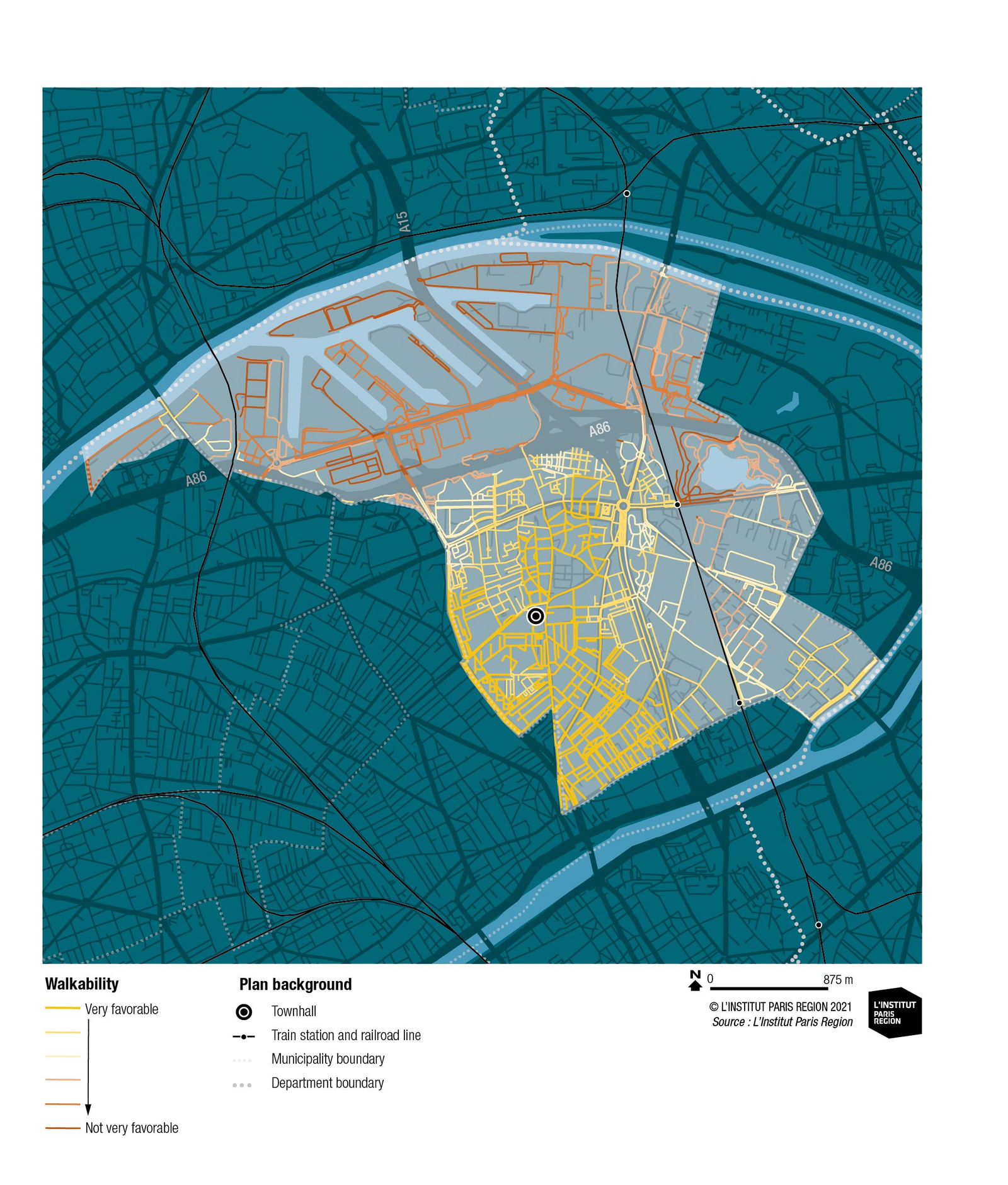
This commune is marked by its port and logistics activity, a neighborhood in the north of the city not very favorable to waling, and many urban cutoffs linked to the presence of road and rail rights-of-way. A city center around the townhall is suggested thanks to the presence of various businesses and facilities.
This index was built using the quantitative spatial characteristics currently available under SIGR6 having a positive or negative influence on walking in the city, such as the presence of sports, health or school facilities, local businesses and other amenities, but also urban heat islands or car traffic (via the number and width of roads). It could be enriched with the availability of new data. For example, those on urban comfort (notably the presence, width and surface of “sidewalks”) and those on urban furniture (foundations, benches, lighting, etc.). or on noise or street lighting, data unavailable on the regional scale. However, even while having all the quantitative elements on the public space, this index cannot describe the quality of the urban ambience: it fluctuates during the day, the seasons and from one individual to another, according to his or her gender, age, among other factors. The absence of noise and other disturbances in a space and the presence of amenities is not always enough to have the feeling of urban comfort emerge. Depending on individual criteria, this feeling is neither unanimous nor stable over time. It requires adapted survey and observation methods like those the Danish urbanist Jan Ghel has largely developed.
Livable city, walkable city
At the start of the 2000s, different cities in the world, including Paris, noted a return to walking in the city1. Today, reinforced by the concerns linked to the health crisis, this subject has returned to urban development debates, in France as well as internationally. This chronicle queries the ideal ingredients of the urban living environment needed to develop walking.
Confronted with the alarming growth of illnesses linked to the sedentary life-style in the United States, a link between cause and effect was rapidly established with the urban forms of American cities characterized by the omnipresence of cars. To counter the effects of urban sprawl, cities attempted to revitalize their center by allocating certain streets to pedestrians (first mall2 in Kalamazoo, Michigan, then in Fresno, California). Starting in the 1960s, American urban planners undertook a reflection on the factors that would encourage walking and those that would curb it3. After having observed the public spaces of European cities, they deduced that a “walkable” city would have several elements favorable to this practice such as the urban grid, the presence of businesses and other landscape or patrimonial points of interest, but also comfort elements such as fountains, benches, shady spaces…
The fundamental qualities of a walkable city
Summed up by the term “walkability”4, these qualities represent the pedestrian potential of a territory, that is, its capacity to encourage going places on foot.
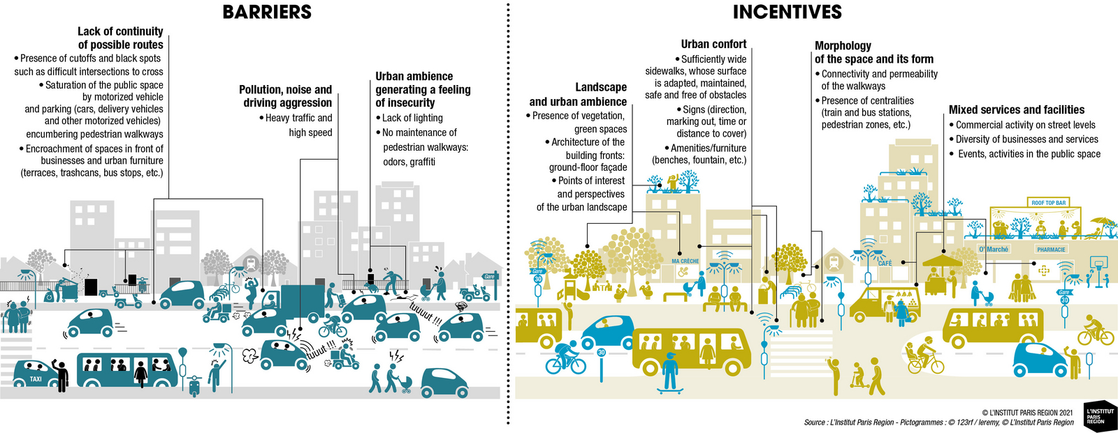
The connectivity and permeability of streets are the first elements that determine the walkability of an urban territory. A dense street grid enables pedestrians to limit detours and offers them several itineraries. Streets that permit direct, safe and pleasant routes are more attractive and more frequently used by pedestrians.
The compactness of an urban zone (urban islands of an optimal length of 60 to 120 m) as well as streets laid out in grids at a regular interval provide better porosity of the built fabric as well as active modes of going from one place to another.
City-dwellers walk more when streets and amenities intended for pedestrians link the city’s main destinations and combine several destinations at the same time (train and bus stations, local businesses, administrative buildings, schools and sports facilities, for example).
The incentive to walk very much depends on the density of housing and mixed land use. The dual presence of services and facility makes it possible to both meet the walkers’ different needs such as stopping, drinking and eating and offering them points of interest and a reference point in space. Consequently, the location of public transportation near one’s home or workplace is an incentive to walk. People who use public transit to go to work walk (going to the departure station, changing lines and going from the arrival station to the final destination), in the end, as much as those who go to work on foot!
The incentive to walk, furthermore, involves a judicious installation of the building on its site and a good insertion into the environment. It is important to work on the interfaces between the building and the street, between the site and the neighborhood, to ensure that they are favorable to pedestrians. From this viewpoint, local business activity has a cardinal role.
The presence of vegetation, green spaces and river banks favors walking as these elements contribute to the improvement of the space’s urban ambience and therefore make it more attractive. For example, greened streets that give priority to active mobilities and notably to pedestrians, make it possible to install nature in the city and consequently help cool it while fighting air pollution. Likewise, discontinuity in land use allows the intrusion of nature into the city and the creation of green spaces.
Perceptual aspects such as safety and aesthetics are important factors in encouraging or restricting walking.
Pollution, noise and aggressive driving are sources of environmental stress on which a pedestrian has little or no control, except for the choice of an itinerary.
The national barometer on walking launched in 20215 permitted the survey’s respondents to provide their opinion on incentive factors and obstacles to walking.
The public space, the cornerstone of walkability
The quality of the public space is important for determining walkability. The public space must not be just a passageway without risking creating the feeling of crossing a non-space. It must be a genuine living space. The more it welcomes a large range of civic, cultural, communal activities (markets, outdoor shows and art exhibitions, sports activities, etc.), the more this space is defined as urban and will encourage its inhabitants and visitors to walk. The creation of an urban ambience involves work on the development of the public space, the siting of businesses and other amenities, but also pays particular attention to the choice of materials, urban furniture and the use of trees, plants and green spaces.
Nevertheless, walkability varies from one neighborhood to the other, from one street to another. To give an account of the diversity of the walking potential according to the city’s neighborhoods, what should ideally be done is to combine the quantified physical characteristics and other data on the urban qualities that take part in the perceived comfort (transparency, perspective, human scale, etc.) and the personal impressions collected during surveys or dialogues with a neighborhood’s users.
Focus on the walkability potential of Gennevilliers
For a sensitive approach to urban design
Defining what a walkable city is does not mean creating a standard urban model that would doom public spaces to uniformization. It means advocating for a sensitive approach to walking and the qualitative development of public spaces. It means reversing the view on public spaces and basing it on pedestrians rather than on traffic flows. Obviously, each place must remain singular and take part in the soul of the city. The city must adapt itself to walking, to welcoming all the pedestrians, including taking into account basic needs like the presence of public lavatories.
So what should be done to create “livable cities”? In large, dense cities, open spaces are increasingly rare and precious. Attributing a sole function to them would definitely limit their attractiveness. It is therefore desirable to permit diversified uses in them: strolling, going from one place to another, games, sports, restaurants, relaxation, cultural and commercial activities and so on. These uses are to be imagined in a dialogue with the resident population and the users while accepting that they will evolve over time, so goes the city!
Teodora Nikolova
Teodora is an engineer and architect-urbanist. She works at the Institut Paris Region’s Urbanism, Development and Territories department where she developed expertise in urban planning, architectural design, transportation, the urban landscape and public health. She notably coordinated the special feature Territoires, incubateurs de santé ? and recently published a Note rapide on the active design of public spaces.
Gaëtane Carette
Gaëtane Carette is a GIS analyst at the Mobility and Transportation department of the Institut Paris Region. Holding a master’s degree in geomatics applied to urban studies and risks from the Université de Cergy, she works, among others, on the subject of active mobilities and is developing a mapping tool on the walkability of communes in the Paris Region.
Frédérique Prédali
Frédérique is an urbanist specializing in transportation and holds a doctorate in mobility from the École d’Urbanisme of Paris. She works at the Mobility and Transportation department of the Institut Paris Region where she has carried out numerous studies on transportation and benchmark policies and has focused on subjects prefiguring the mobility of tomorrow. She is involved in a European project on managing energy to have it meet the needs linked to electro-mobility and renewable energy production. She recently published a study of electric vehicle charging infrastructures and a Note rapide on the quality of service in public transportation. She is coordinating this series of chronicles on walking.
1. F. Papon and R. de Solère, 2009, “Les modes actifs : marche et vélo de retour en ville,” La Revue du SOeS, CGDD.
2. The first malls in 1960 were not shopping centers but streets with a landscaped commercial vocation dedicated to pedestrians.
3. Let us cite the works of Lewis Mumford (The City in History, 1961) and Jane Jacobs (The Death and Life of Great American Cities, 1961), founders of the movement for a new urbanism that includes the pedestrian question in urban development.
4. The “walkability” concept emerged in the United States in the 1990s.
5. Place for pedestrians, Baromètre des villes marchables, September 2021.
6. Geographic information system.
This page is linked to the following categories :
Mobility
|
Urban planning